The pre-gunpowder wall
Before artillery existed, the logic of fortification was straightforward: build tall, build thick, and project towers so defenders could fire along the face of the wall and catch attackers in a crossfire. Height was an asset rather than a liability. An enemy trying to scale a 10-meter curtain wall under arrow fire faced a formidable problem, and the physics of pre-gunpowder siege engines — trebuchets, mangonels, battering rams — made rapid demolition of well-built stone walls extremely difficult.
The Romans understood flanking fire early and applied it systematically. The Aurelian Wall (Rome, 271 AD), built to defend a city grown too large for its earlier circuit, runs for nearly 19 kilometers with projecting towers spaced roughly every 30 meters. Each tower commands the stretch of wall on either side, meaning any attacker approaching the wall face is exposed to arrows from at least two towers simultaneously. This principle — that the wall itself is not just a barrier but a firing platform for flanking fire — remained the central logic of defensive architecture for more than a thousand years.
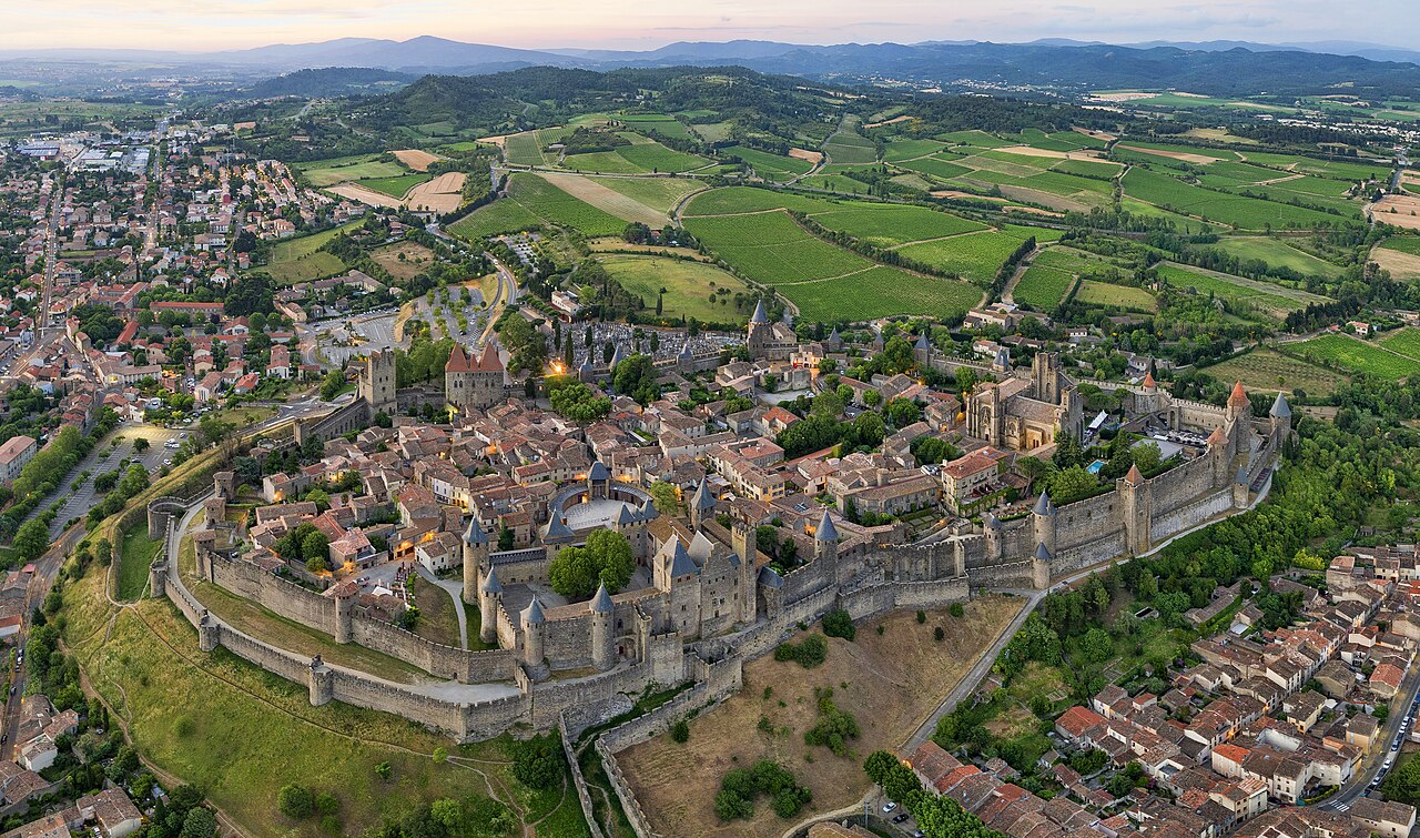
Medieval city walls elaborated this principle into concentric systems. Carcassonne (France), reconstructed in the 13th century under Louis IX and later restored by Viollet-le-Duc, presents two complete circuits of wall with towers, an outer and an inner, so attackers who breached the outer wall found themselves trapped in a killing ground between the two. Dubrovnik (Croatia), whose walls were built and rebuilt between the 13th and 17th centuries, still stand almost completely intact and illustrate how a prosperous maritime city invested continuously in its defenses.
The gatehouse was always the most heavily fortified point in any city or castle wall, because it was the necessary weak point — you had to have an opening, and that opening attracted attack. Medieval gatehouses layered defenses in depth: a portcullis (an iron or iron-shod timber grille that could be dropped rapidly from above) at the outer face, followed by a passage that turned at a right angle inside the thickness of the wall, defeating the momentum of any battering ram. Murder holes — openings in the ceiling of the gate passage — allowed defenders above to pour boiling water, hot sand, or arrows down onto attackers who had pushed past the portcullis but not through the second door. The combination of portcullis, murder holes, and a right-angle turn inside the gate passage made a well-designed gatehouse nearly impregnable to anything short of a prolonged siege.
The keep and the motte-and-bailey
While city walls protected populations, the castle proper was a different kind of structure: a fortified residence for a lord and garrison, designed to dominate a territory and serve as the final refuge in case of attack. The earliest Norman castles, built rapidly across England after the Conquest of 1066, used the motte-and-bailey plan: a wooden tower atop an artificial earthen mound (the motte), connected by a bridge to a fortified enclosure at ground level (the bailey) where horses, stores, and the garrison lived. The genius of this design was speed — earth could be piled and timber cut in weeks, giving the Normans a network of fortresses across conquered England before any serious resistance could organize.
The motte-and-bailey had severe weaknesses. Wood decays rapidly, especially in wet climates. The earthen mound compacted and subsided under the weight of a tower. Most Norman motte-and-baileys that survive at all survive only as earthworks — the characteristic conical mound and rectangular enclosure visible as grassy humps in English fields. Where lords had the resources and the time, they rebuilt in stone. The stone keep — a tall, rectangular masonry tower serving as stronghold and lord's residence — became the dominant castle form of the 11th and 12th centuries.
The White Tower at the Tower of London (begun 1078 under William the Conqueror) is the earliest and most complete example of a Norman stone keep in England. Its walls are over four meters thick at the base, its corners are slightly rounded to deflect missiles, and its entrance was originally at first-floor level with access only by an external wooden stair — which could be removed in an emergency, leaving the keep completely inaccessible from below. The design is simultaneously residence (the upper floors contain a great hall, private chambers, and the Chapel of St John) and military stronghold.
Round keeps emerged in the 13th century to solve a problem that had plagued rectangular towers: corner-undermining. Attackers could dig beneath a corner of a rectangular keep, shore up the cavity with timber, then burn the timber — the corner would collapse, bringing down a section of wall. A round tower had no corners, making this technique much harder. But the keep itself was being superseded by a more sophisticated approach: the concentric castle, with multiple rings of walls each higher than the last, so defenders on the inner wall could fire over the heads of defenders on the outer wall. Beaumaris Castle (Wales, begun 1295 under Edward I) is the most perfect surviving example of the fully developed concentric castle — never actually finished, but its plan reveals the ideal of an absolutely regular, geometrically precise defensive system in which every part of every wall is covered by fire from somewhere else.
Gunpowder and the star fort
The invention and gradual improvement of gunpowder artillery transformed fortification more completely than any previous technological change. By the mid-15th century, cannon firing iron balls were capable of reducing stone walls that had defied siege engines for centuries. The fall of Constantinople in 1453 to Ottoman artillery — including enormous bombards — demonstrated that the age of the high medieval curtain wall was over. The same walls that had protected the city for a thousand years crumbled under sustained bombardment in weeks.
The problem was not simply that cannon balls hit hard. It was that high stone walls, when hit by artillery, generated lethal secondary effects: fragments of shattered masonry traveling at high velocity, falling debris, and partial collapses that created new breaches. A tall wall that had deterred escalade was now a source of cascading structural failure. The psychological security of high walls became a physical liability.
The solution was developed in Italy in the late 15th century and refined through the early 16th century. The key insight was to lower the walls and thicken them massively, replacing vertical stone faces with sloped earthen banks (called ramparts or glacis) that absorbed cannonballs by deflecting and burying them rather than shattering. At the same time, the projecting tower was redesigned as the bastion: a pointed, diamond-shaped projection from the main wall, with two faces angled outward and two flanks set back. The angled faces of one bastion are swept by fire from the flanks of the adjacent bastions — meaning that an attacker approaching any point of the wall is exposed to flanking fire from at least two bastions simultaneously. There are no blind spots.
The consequence of this flanking-fire geometry is the distinctive plan shape that gives the star fort its name. Seen from above, the alternation of bastions and curtain walls creates a multi-pointed star or polygon. This is not decorative — it is the direct geometric consequence of the requirement that every part of every wall be covered from somewhere. The trace italienne (Italian plan), as this system was called, spread across Europe and eventually to every part of the globe touched by European military power. A star-shaped fortification anywhere in the world almost always indicates a connection to European military engineering traditions of the 16th through 18th centuries.
Vauban and the perfection of the bastion fort
Sébastien Le Prestre de Vauban (1633–1707) was the greatest military engineer of the 17th century and arguably of any century. As chief engineer to Louis XIV of France, he built, rebuilt, or significantly modified more than 150 fortresses along France's borders, creating a defensive belt that shaped European warfare for more than a century. More than that, he systematized the design of both fortresses and sieges — developing a rational, reproducible method for each that reduced both the cost of construction and the duration of sieges.
Vauban's additions to the bastion system went beyond improving the bastions themselves. He added a comprehensive outer ring of smaller detached works: the ravelin, a small triangular outwork placed in the ditch in front of each curtain wall, protecting the gate and preventing direct artillery fire on the main wall; the tenaille and counterguard as additional protective screens; and the covered way, a sunken path at the outer edge of the ditch giving defenders a protected route to outposts. The whole system functioned as a machine for making sieges expensive and predictable — and Vauban designed the attacking side of this machine as rigorously as the defensive side, publishing a method of parallel trenches and battery positions that reduced most sieges to a known number of days.
The Citadelle de Lille (1670) shows Vauban's system at its most elegant: a pentagonal citadel with five bastions and five ravelins, placed at the corner of a bastioned town enceinte. Neuf-Brisach (1706), built from scratch on a flat Alsatian plain, is perhaps the clearest surviving demonstration of his mature system: an octagonal plan with eight bastions, eight ravelins, and every geometric relationship calculated for maximum mutual support. Vauban's fortifications were inscribed collectively as a UNESCO World Heritage Site in 2008 — not as individual monuments but as the surviving components of an integrated defensive system, demonstrating a complete military engineering philosophy.
The Vauban system spread beyond France through the training of engineers and the publication of treatises. Dutch, Prussian, Swedish, and later British and Russian engineers all worked within frameworks derived from his methods. The bastioned fort of the 17th and 18th centuries is therefore a global type — the same geometric principles appear in European border fortresses, in colonial trading post forts in Africa and Asia, in the fortifications of the American colonies, and in the defenses of the major port cities of India and the Caribbean.
Coastal and colonial forts
Coastal fortifications presented a different set of design problems from inland frontier forts. A coastal battery was not designed to resist a land-based siege — it was designed to prevent enemy warships from entering a harbor or bombarding a port. The attacker was a floating gun platform firing from the sea; the defender needed to present as small a target as possible while bringing as many guns as possible to bear on the water approaches. The solution was a low, massive structure with thick earthen or masonry parapets that could deflect the relatively flat trajectory of naval gunfire, oriented to cover the harbor mouth.
The Portuguese and Spanish empires of the 16th century built coastal fortifications across the Indian Ocean and Atlantic as the physical infrastructure of global trade. Fort Jesus (Mombasa, Kenya, 1596), designed by the Italian military architect João Baptista Cairato, adapts the bastion plan to a coral headland guarding the approach to Mombasa harbor — its plan is roughly rectangular with four bastions, each named after a saint, its walls rising from the coral rock. Fortaleza de São João Baptista (Angola, begun 1575) and the series of Portuguese forts along the Indian coast at Diu, Daman, and Goa similarly use the bastion plan adapted to coastal headlands and available local stone.
British coastal fortification of the 18th and 19th centuries produced a distinctive type: large, polygonal or bastioned forts built in red or yellow brick, designed as much for permanent garrison and artillery storage as for active defense. Fort George (near Inverness, Scotland, completed 1769) is the finest surviving example of 18th-century British military engineering — its plan visible in aerial view as a long, angular peninsula of earthworks projecting into the Moray Firth. Fort Jefferson (Dry Tortugas, Florida, begun 1846) is among the largest 19th-century American coastal forts: a massive hexagonal structure built in brick on a coral island, its walls rising from the water. For game players, a large star-shaped or bastioned structure situated near water or on a coastal headland almost invariably indicates a Portuguese, Spanish, Dutch, or British colonial trading post fort, typically dating from the 16th to 18th centuries.
19th-century fortifications: the polygonal and the earthwork
The introduction of explosive shells in the 1820s and 1840s created a new crisis for masonry fortification. A cannonball, however large and fast, struck a wall and transferred its energy to that single point. An exploding shell, by contrast, detonated within or behind a masonry wall and generated a pressure wave that could demolish large sections in a single blast. The thick masonry walls of bastioned forts — already heavily built to resist cannonball impact — proved catastrophically vulnerable to explosive shells. Masonry that had taken years to build could be brought down in hours.
The response was the polygonal or New Prussian system, and eventually the full earthwork fort. Rather than relying on masonry for all defensive functions, engineers began burying masonry structures behind massive earthen parapets that absorbed and dissipated explosive energy. The polygonal fort replaced the angled bastion with a simple straight-sided polygon — the flanking fire problem was solved by caponieres (underground caponiers: vaulted masonry galleries projecting into the ditch, with gunports in the sides) rather than by projecting bastions above the parapet level.
Fort Pulaski (Georgia, completed 1847) illustrates the transitional period: a brick pentagon behind a wide earthen glacis, its masonry walls eventually breached by rifled artillery in 1862 during the American Civil War. The Civil War proved that field fortifications of earth and timber were more effective than masonry — a lesson that accelerated the transition to earthworks across the world. By the late 19th century, permanent fortifications had gone largely underground: reinforced concrete replaced masonry, guns were mounted in retractable turrets flush with the parapet, and the entire structure was designed to be invisible from outside. The Maginot Line (France, built 1930–1936) represents the logical endpoint of this evolution: an underground city of barracks, rail lines, ammunition stores, and artillery positions, almost entirely invisible from the surface. The question of what a fortification should look like had been answered by making it disappear entirely.
Identifying fortifications in the game
Military fortifications are among the easiest building types to categorize broadly once you know the key markers, but they require careful attention to plan shape, construction material, and relationship to water and topography.
A multi-towered curtain wall on a hill with no evidence of artillery positions — no bastions, no wide earthen banks, no low profile — indicates a medieval castle or city wall, almost certainly European and almost certainly pre-1500. The towers will be circular or square, the walls will be high relative to their thickness, and the gatehouse will be the most elaborate element. If the wall is urban rather than a single castle, and if multiple circuits are visible, it is likely a major medieval city: Carcassonne, Dubrovnik, Avila, Rothenburg ob der Tauber.
A star-shaped or clearly bastioned plan, visible either from an elevated viewpoint or from the characteristic projecting angles of the walls, indicates a trace italienne fort — most likely 16th, 17th, or 18th century. Location narrows it further: in Europe, it is likely a border fortress (French, Dutch, German, Swedish, or Prussian frontier); on a tropical coastline or harbor, it is almost certainly a Portuguese, Dutch, British, or Spanish colonial fort. The construction material varies — stone in Europe and coastal Africa, coral and lime plaster in East Africa and the Caribbean, brick in North America and India — but the geometry is immediately recognizable.
A low, massive structure near water with thick earthen banks and few or no visible towers — especially if built in brick — suggests a coastal battery or 19th-century polygonal fort. These are common in the British Isles, the northeastern United States, and around major colonial harbors. They often read as broad, low polygonal platforms rather than the spiky outlines of earlier star forts.
Underground or bunker-style structures with reinforced concrete construction, blast doors, ventilation shafts, and artillery turrets flush with the landscape are 20th-century fortifications — anywhere from the Atlantic Wall of World War II Europe to Cold War missile installations. The Maginot Line, the Atlantic Wall, and the Finnish Mannerheim Line are the most famous, but similar structures exist on every continent.
Finally, abandoned star forts on tropical coastlines in deteriorating condition, typically with cannon still in place on decaying carriages and vegetation growing through the walls, are almost certainly Portuguese, Dutch, or British colonial-era forts from the 16th to 18th centuries. The combination of tropical setting, bastioned plan, and visible cannon is one of the most reliably identifiable signatures in the entire game. For more context on medieval defensive structures, see our piece on castles: myth vs reality, and for the broader relationship between buildings and power, see the architecture of power.
Regional Variations in Military Fortifications
The medieval European castle shares the curtain-wall-and-tower typology with fortifications found across the Islamic world, but the two traditions developed in largely parallel rather than directly exchanged ways. Crusader castles in the Levant — Krak des Chevaliers in Syria, Belvoir in Israel — combine the concentric principles developed in Europe with local stone-cutting traditions and climate-driven modifications (deeper cisterns, more shade-oriented planning). Krak des Chevaliers, built by the Knights Hospitaller from the 1140s onward, preserves an almost complete concentric plan with an inner and outer ward, a great hall, and towers of both square and round plans — a rare survival of a high-medieval military complex at nearly full scale.
Mughal forts occupy a distinct typological space between the purely military and the palatial. Agra Fort (built largely under Akbar from 1565) and Lahore Fort (substantially rebuilt under Jahangir and Shah Jahan) are double-walled enclosures with massive red sandstone curtain walls and towers, but their interiors contain elaborate palace complexes, mosques, gardens, and audience halls that rival contemporary European royal residences. The Mughal fort was not merely a defensive structure but the physical seat of imperial administration and ceremony — the wall is defensive, but everything behind it is designed for governance and display. This dual function is visible in the contrast between the rough military exterior and the refined marble-inlaid interior spaces.
Chinese frontier fortification, most famously the Great Wall (built in multiple phases from the Warring States period through the Ming dynasty), differs from European castle architecture in its emphasis on linear control of territory rather than point defense. The Wall is not a single structure but a system of walls, watchtowers, garrison stations, and signal towers stretched across thousands of kilometers of terrain — a monitoring and communication network as much as a physical barrier. Its purpose was to control the movement of steppe peoples and regulate trade, not to resist prolonged siege in the European sense. The Ming-dynasty sections most commonly photographed (near Beijing, at Mutianyu and Badaling) use fired brick over an earth core, with crenellated walkways along the top and square watchtowers at regular intervals.
Roman frontier walls work on a similar linear logic but at a more modest scale. Hadrian's Wall (begun 122 AD) in northern Britain runs 117 kilometers from the Solway Firth to the Tyne, with milecastles (small forts at every Roman mile) and signal towers between them. Unlike the Great Wall, Hadrian's Wall was not designed to stop a large invasion — Roman field armies did that — but to monitor and tax cross-border movement and deter small-scale raiding. The wall itself was a statement of Roman territorial control as much as a military barrier, marking where Roman civilization ended and the barbarian world began. The contrast with Vauban's geometrically sophisticated star forts of the seventeenth century illustrates how dramatically the purposes and engineering of frontier fortification changed over fifteen centuries.
Key Military Fortification Identifiers
- Bastion: the protruding angular platform projecting from a curtain wall for flanking fire — the defining element of the trace italienne star fort
- Ravelin: the small triangular outwork placed in the ditch in front of a curtain wall — protects the gate and prevents direct artillery fire on the wall behind it
- Glacis: the sloped earth ramp extending from the outer ditch — designed to deflect cannonballs by ricocheting them upward rather than allowing direct impact on the wall
- Casemate: a vaulted chamber within the thickness of a wall or beneath a rampart — used for gun emplacements, troop quarters, or ammunition storage; protects its occupants from artillery fire
- Barbican: an outer gatehouse or fortified outwork protecting the main gate — creates a double-entry sequence that forces attackers through a second defended passage
- Machicolation: projecting floor openings at parapet level — allowed defenders to drop stones, boiling water, or arrows directly down onto attackers at the base of the wall
- Curtain wall: the main connecting wall between towers or bastions — carries the defended perimeter between active defensive positions
- Keep (donjon): the main residential tower of a medieval castle — the last defensive refuge and the lord's primary residence; square in early Norman examples, round from the thirteenth century to defeat undermining
- Portcullis: the vertically sliding iron or iron-shod timber gate — dropped rapidly from above to seal a gate passage; used in combination with murder holes and a turning passage to create a defended gate trap
A Closer Look: Vauban's Citadel of Lille
The Citadelle de Lille, designed by Sébastien Le Prestre de Vauban and constructed between 1667 and 1670 after Louis XIV's capture of the city from Spanish forces, represents the mature Vauban system at a moment when its designer was still refining his methods. The citadel is a regular pentagon with five bastions and five ravelins — one at the center of each curtain wall — set within a wide wet ditch and surrounded by a glacis that slopes gently away on all sides, presenting no vertical surface for an attacker's battery to target. The pentagonal plan was dictated by practical geometry: a regular polygon with five sides allows each bastion's flanks to provide mutual fire support across the curtain walls while maintaining a compact perimeter that minimizes the garrison required to defend it.
Vauban's innovation in the Lille citadel and subsequent works was not the individual bastion — that had been standard European practice for over a century — but the systematic integration of all elements into a coherent machine. The covered way (a sunken path at the outer edge of the ditch, protected by a continuous parapet) allowed defenders to move between positions under cover. The ravelins in front of each curtain wall prevented direct artillery fire on the main wall while allowing the bastions to fire across the ravelin faces. The glacis beyond the covered way meant that an attacker's approach trenches had to traverse a long exposed slope under flanking fire before reaching the ditch. Every element of the system was designed not just to defend statically but to make any attacking approach maximally costly in time and casualties.
The result was a style of fortification that was replicated across the world wherever European military engineering carried influence. The same pentagonal or star-fort geometry appears in the Dutch colonial fort at Galle in Sri Lanka, in the Spanish fortifications at Havana and Cartagena, in the British forts of the North American colonies, and in the Portuguese strongholds along the East African coast. When you see a five-pointed star or a clear bastioned polygon from above — especially in a tropical coastal setting, or on a European river or mountain pass — the probability is high that you are looking at a structure derived, directly or indirectly, from the Vauban tradition, even if the original engineer has been long forgotten.
Spotting It in Building Guessr
Pre-gunpowder fortifications have round towers and high curtain walls. The towers are circular or square, tall relative to the wall, and the entire defensive system emphasizes vertical height — scaling ladders were the primary assault tool, and height was the defender's primary advantage. If a fort in the game has high walls, round towers at the corners, and a prominent gatehouse as the most elaborate element, it is almost certainly a medieval structure, pre-1500, and most likely European. If the same wall plan is applied at urban scale with multiple circuits visible, the location is likely a well-preserved medieval city: Carcassonne, Dubrovnik, Avila, or the old cities of Morocco and the Middle East.
Post-gunpowder fortifications, by contrast, have low profiles, angled star-shaped bastions, and visible earthworks. If you see a building complex that looks like a five-pointed star, or any clearly geometric angular layout with diamond-shaped corner projections and a wide, flat surrounding zone (the glacis and ditch), it is almost certainly a sixteenth through eighteenth century artillery fort of the trace italienne type. The construction material and the landscape context will narrow the location further: dressed stone in a temperate European climate suggests France, the Netherlands, or Britain; coral and lime plaster in a tropical harbor setting suggests Portuguese or Dutch colonial work; red brick in a North American or Caribbean setting suggests British colonial fortification. In all cases the star-fort geometry is the primary identifier, and it is one of the most immediately recognizable plan shapes in the entire game.
Try the game's filter for castles and fortifications.
Play Building Guessr