What it is
Stonehenge is a prehistoric ceremonial monument on Salisbury Plain in Wiltshire, southern England, consisting of a circular arrangement of massive standing stones set within a broader complex of earthworks, burial mounds, and processional avenues. It is the most architecturally sophisticated prehistoric stone circle in the world, and one of the most visited archaeological sites in Europe. The monument's meaning — what it was used for, who built it, and why its builders went to such extraordinary effort to assemble it — has been debated for centuries and remains incompletely understood. What is clear is that it was not built all at once but developed through a series of distinct construction phases spanning approximately 1,500 years, from about 3000 BCE to 1500 BCE.
Stonehenge sits within a wider sacred landscape. The surrounding area contains hundreds of associated monuments: long barrows, round barrows, processional earthworks, timber circles, and the massive enclosures of Durrington Walls and Woodhenge, located approximately 3 kilometres to the northeast. This landscape — now designated a UNESCO World Heritage Site along with the monument itself — suggests that Stonehenge was the focal point of a ceremonial complex serving a substantial region of southern Britain, used for purposes ranging from ancestor veneration and seasonal ceremony to the treatment and burial of the dead.
The three main phases of construction
Phase 1 (c.3000 BCE) began with the creation of a circular earthwork: a ditch dug into the chalk, with the excavated material used to form an internal bank. Inside the bank, a ring of 56 chalk-filled pits was dug — now known as the Aubrey Holes, named for the 17th-century antiquary John Aubrey who first noticed them. These pits contained cremated human remains, and the monument at this stage appears to have functioned primarily as a cremation cemetery. Fragments of bluestones — the distinctive spotted dolerite from the Preseli Hills of west Wales — are found in early contexts at the site, suggesting that some stones may have been present from this initial phase, though this remains debated.
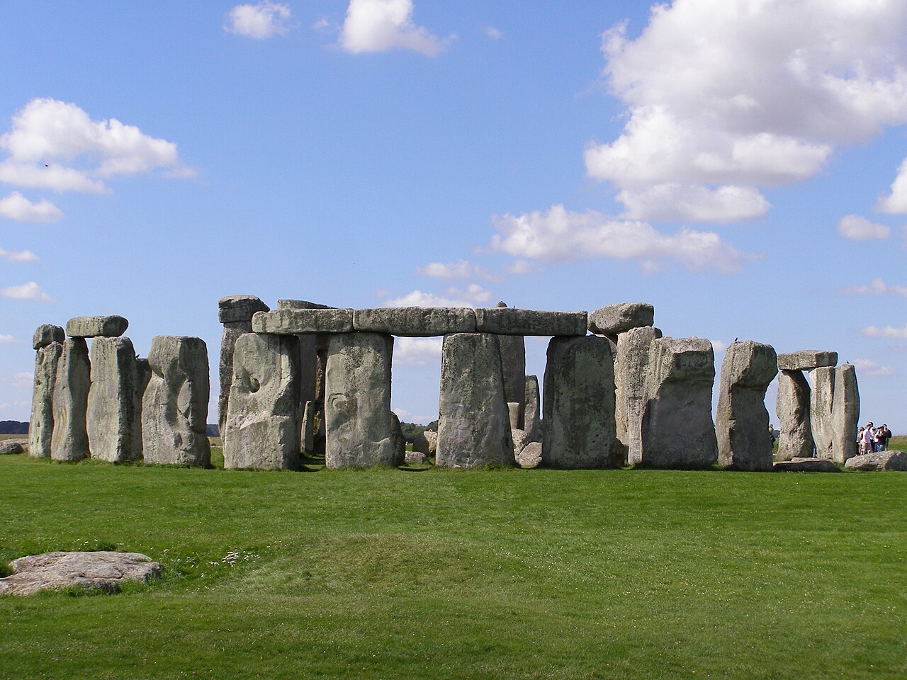
Phase 2 (c.2500 BCE) represents the most dramatic transformation: the erection of the massive sarsen stones that form the iconic trilithons and outer circle still visible today. Sarsen is a hard silicified sandstone found naturally as surface boulders on the Marlborough Downs, approximately 25 kilometres to the north. The largest sarsens weigh up to 25 tonnes and were transported to the site — by a combination of wooden sledges, rollers, and possibly river transport — over a distance that makes even modern heavy-lift operations seem modest by comparison. The stones were shaped using stone mauls (balls of sarsen used as hammers) and dressed to a smooth surface. The uprights of the outer circle were connected by curved lintels using a sophisticated mortise-and-tenon jointing system: a rounded tenon protruding from the top of each upright fits into a corresponding mortise socket cut into the underside of the lintel. This carpentry technique, borrowed from woodworking and translated into stone, locked the lintels in place and gave the structure a rigidity that has allowed many sections to survive four millennia of weathering, frost, and ground movement.
Phase 3 (c.2000–1500 BCE) involved a series of rearrangements and additions to the interior of the monument, including the repositioning of the bluestones — volcanic rock from the Preseli Hills in Pembrokeshire, Wales, approximately 240 kilometres away — into their current oval and inner horseshoe configurations. The transport of these stones, weighing two to four tonnes each, across that distance — whether overland using sledges and rollers, by sea and river, or some combination — represents a logistical achievement whose precise method remains actively debated. The motivation for obtaining stone from such a remote location, when adequate local stone was available, suggests that the bluestones held specific cultural, spiritual, or medicinal significance to the people who quarried them.
Astronomical alignment
Stonehenge's most celebrated feature is its astronomical alignment. The monument is oriented so that its principal axis — running from the centre of the stone circle along the Avenue, the 2.8-kilometre processional earthwork approaching from the northeast — points directly toward the point on the horizon where the sun rises on the midsummer solstice (around 21 June). Standing at the centre of the monument and looking along this axis, the midsummer sunrise appears over the Heel Stone, a large unworked sarsen that stands just outside the entrance. In the opposite direction — looking from the northeast entrance back through the monument to the southwest — the midwinter sunset aligns through the great trilithon, the largest pair of uprights. This dual alignment, encompassing both the longest and shortest days, strongly suggests that Stonehenge was a calendrical monument tied to the solar year and to the seasonal ceremonies and agricultural rhythms that depended on it.
Key elements
- Trilithons: Five trilithons — each consisting of two tall upright sarsens supporting a horizontal lintel — arranged in a horseshoe shape at the centre of the monument. The largest surviving trilithon has uprights approximately 7.3 metres tall above ground (with a further 2.4 metres buried), making it the tallest prehistoric stone structure in Britain.
- Outer sarsen circle: Originally 30 upright sarsens and 30 lintels forming a continuous ring, of which approximately 17 uprights and 6 lintels are still standing. The lintels are slightly curved to follow the circle and are secured by mortise-and-tenon joints.
- Aubrey Holes: 56 chalk-filled pits forming a ring just inside the earthwork bank. Cremated remains of approximately 64 individuals have been found in and around these pits, suggesting the monument's earliest function was as a burial ground.
- Altar Stone: A large block of green Devonian sandstone lying flat near the centre of the monument, believed to have once stood upright. Its origin — unlike the bluestones — remains disputed, with recent research suggesting a source in Scotland.
- Slaughter Stone: A large fallen sarsen near the entrance, originally one of a pair (or possibly four) of portal stones framing the entrance to the monument. Its grim popular name derives from the red iron staining in its surface depressions, once interpreted as sacrificial blood — in fact simply oxidised rainwater collecting in stone-tool marks.
- The Avenue: A 2.8-kilometre processional earthwork — two parallel banks and ditches — running from the monument's northeast entrance toward the River Avon. Recent evidence suggests its alignment may follow a natural periglacial landform (a glacially formed drainage channel) that coincidentally pointed toward the midsummer sunrise, potentially explaining why this specific location was chosen for the monument.
Investigation and legacy
Stonehenge has attracted antiquarian and scientific attention for centuries. The 18th-century antiquary William Stukeley produced the first systematic survey drawings of the monument and the surrounding landscape, correctly associating the monument with its solar alignment and introducing the term "trilithon." He also, less helpfully, enthusiastically attributed the monument to the Druids — a misattribution that persisted in popular culture for two centuries despite the fact that the Druids did not appear in Britain until around 600–500 BCE, more than a thousand years after Stonehenge's completion. Modern geophysical survey techniques — ground-penetrating radar, magnetometry, and LiDAR — have in recent decades revealed dozens of previously unknown monuments buried beneath the surrounding landscape, dramatically expanding understanding of Stonehenge as a node in a much larger ceremonial network rather than an isolated monument.
Think you can place this building on the map?
Play Building Guessr