What it is
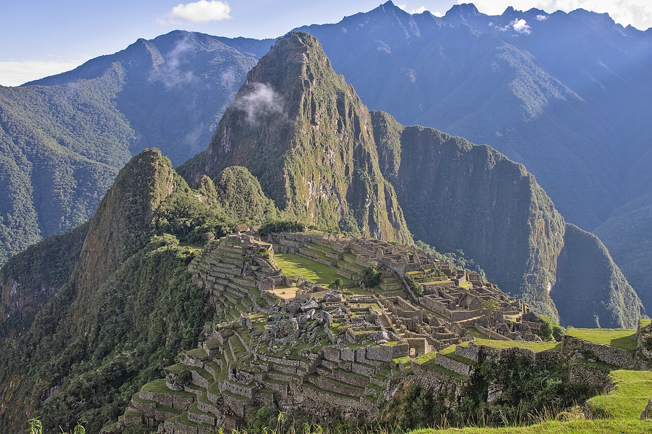
Machu Picchu sits at 2,430 meters above sea level on a narrow ridge between two mountain peaks — Machu Picchu ("Old Peak") and Huayna Picchu ("Young Peak") — in the cloud forest of southern Peru, 80 kilometers northwest of Cusco. It was almost certainly built as a royal estate for the Inca emperor Pachacuti Inca Yupanqui around 1450 CE and was inhabited for approximately 120 years before being abandoned around 1572, likely as a result of the Spanish conquest of the Inca Empire. Its abandonment — and the subsequent overgrowth by cloud forest — meant that the Spanish conquerors who systematically looted and destroyed Inca cities never found it. The site became known to the outside world primarily through the visit of American historian and explorer Hiram Bingham III in July 1911, who was actually searching for Vilcabamba, the last Inca capital, when a local farmer guided him to the ruins instead. Bingham's photographs and subsequent publications in National Geographic brought Machu Picchu to international attention and made it the defining image of the Inca civilization for the Western world.
The site's function remains a subject of scholarly debate, though the consensus view is that it served as a royal retreat for Pachacuti — a place for religious ceremonies, relaxation from the demands of Cusco, and probably agricultural experimentation in the extensive terraced fields on the lower slopes. It was not a city in the sense of a permanent population center; the permanent residents were probably in the hundreds rather than thousands, with larger numbers arriving seasonally. The remarkable preservation of the stone structures — and the dramatic mountain setting — make it Peru's most visited archaeological site, receiving approximately 1.5 million visitors per year before pandemic-era restrictions reduced that figure and prompted ongoing debate about sustainable visitor management.
Architectural significance
The defining technical achievement of Machu Picchu — and of Inca architecture generally — is the ashlar masonry produced without mortar and without iron tools. The Inca had no iron; their metal-working was primarily in gold, silver, and bronze, and they had no wheeled transport. Yet the stone blocks at Machu Picchu, and at other Inca sites such as Sacsayhuamán and Ollantaytambo, are fitted together with tolerances that in some places approach less than one millimeter, with irregular polygonal faces that interlock like puzzle pieces. This was achieved through a process of progressive abrasion — repeatedly lifting one block against the other, marking the high points, and grinding them down — a labor-intensive but geometrically precise technique that produces joints that repel water infiltration and, remarkably, perform well in earthquakes: in a major seismic event, the stones reportedly shake slightly and then resettle into position, whereas mortar-bonded construction cracks and fractures under the same stress.
The entire site is also a masterwork of adaptation to an extraordinarily difficult landscape. The ridge on which Machu Picchu sits is essentially a knife-edge, with near-vertical drops on both sides. The Inca transformed this site through the construction of more than a hundred agricultural terraces (andenes) — retaining walls of stone creating level platforms cut into the slopes, providing both agricultural land and, crucially, a sophisticated drainage system that channels rainfall away from the foundations of the structures above. Approximately 60 percent of the construction at Machu Picchu is underground, in the form of drainage channels and foundation materials, rather than in the visible walls and buildings. The site is, at its engineering core, a solution to the problem of making a mountain ridge habitable.
Key features
- Agricultural terraces on the lower slopes: More than 100 stone-retained agricultural terraces on the slopes below the main urban sector, providing flat cultivable land and serving as the site's primary drainage and erosion-control infrastructure.
- Intihuatana stone: A ritual carved stone in the religious sector whose name means "hitching post of the sun" — it functions as a solar calendar, casting no shadow at solar noon on the equinoxes, and marking the solstices with specific shadow angles; one of only a handful of Intihuatana stones to survive the Spanish conquest intact.
- Temple of the Sun: A semicircular tower of perfectly fitted curved ashlar masonry built around a natural rock outcrop; a window in the curved wall aligns precisely with the rising sun at winter solstice, flooding the interior with light and illuminating a specific stone on the altar below.
- Residential sector: A dense collection of small stone structures believed to have housed the permanent population of retainers, priests, and agricultural workers who maintained the site year-round.
- Religious sector with sacred plazas: The open plazas at the site's highest level, with the Intihuatana, the Temple of the Three Windows, and the Principal Temple, constitute the ceremonial heart of the complex and are positioned to maximize views of the surrounding mountain landscape.
- Panoramic mountain setting: The site is visible in its entirety only from the summit of Huayna Picchu (accessible by a steep trail from the main site) or from the Sun Gate (Inti Punku), the original Inca entrance point at the top of the Inca Trail — the view from both of these vantage points, with the ruins set against the peaks and the Urubamba River thousands of meters below, constitutes one of the most dramatic architectural landscapes on earth.
Preservation status
UNESCO inscribed Machu Picchu as a World Heritage Site in 1983 and has listed it as a World Heritage Site in Danger on multiple occasions since due to the impacts of overtourism, uncontrolled development in the gateway town of Aguas Calientes below the site, and infrastructure pressures. The stone walls are largely intact — roofs, which were of thatch, and wooden elements are gone — and the masonry requires relatively little active intervention because the dry-stone construction inherently tolerates movement without failure. The principal conservation concerns are erosion of pathways and terraces from visitor foot traffic, instability of the hillside slopes on which the site sits (landslides are a recurrent risk in the wet season), and the long-term impacts of human presence on the archaeological deposits within and below the buildings. Visitor limits — set at around 2,500 per day for the main site, with timed entry slots — have been debated and revised repeatedly since 2017, with ongoing tension between conservation requirements and the economic interests of the local tourism industry.
Think you can place this building on the map?
Play Building Guessr